Select a region


Should Jersey build an offshore windfarm to be self-sufficient in electricity? How does Jersey protect sensitive areas like Les Ecréhous when people flock there in the summer? What is the best way to ensure islanders and tourists can enjoy Jersey’s seafood while preventing over-fishing? How will Jersey protect those species most under threat?
These questions – and many more besides – will be addressed in a major piece of work which the Government has pledged to complete by the end of next year.
It will define how the island looks after its 800 square miles of territorial waters, which stretch out 14 miles from the coastline or, to the east, the mid-point between Jersey and France.
Jersey’s marine environment makes up 96% of its territory, with its seas, reefs and inter-tidal zone being about 20 times bigger than its 45 square miles of landmass.
Called the ‘Marine Spatial Plan’, it will be the first time that the management of the island’s ‘marine estate’ will be set out in a single document.
Although born out the Bridging Island Plan – which is a blueprint against which all planning decisions are made – the Marine Spatial Plan will go a lot further, taking into account lots of other considerations, such as fisheries legislation, international conventions the island has signed up to, the impact of Brexit and the island’s drive to achieve net-zero carbon emissions by 2050.
Last year, when the three-year abridged Island Plan was debated and passed, there was an unsuccessful amendment to create a Marine National Park, which would cover around 30% of Jersey’s seas by 2025.
Although many States Members supported the concept of a marine park, the proposal was defeated because the park would have been simply a planning designation – in short, it would have had no legal basis to, for example, ban fishing in sensitive areas.
In short, the Marine Spatial Plan promises to provide the teeth that a Marine National Park would lack.
The Bridging Island Plan sets out the underlying challenge facing the authors of the Marine Spatial Plan.
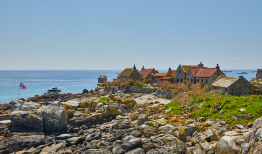
Pictured: Jersey’s reefs are a great source of biodiversity.
It says: “The marine environment is a complex ecosystem where a range of activities and interests occur which extend beyond the sphere of the planning process and the regulation of development activity.
“These include energy generation and transmission, recreation, fishing, shipping and conservation.
“There is, therefore, a significant and strategic opportunity to strengthen the planning and management regime for the marine environment.
“To best manage and to secure the comprehensive and sustainable use of marine and coastal resources, it is proposed to develop a marine spatial plan for the island’s waters.
“A marine spatial plan enables the development of a coordinated and coherent approach to governance and decision making in the marine environment by creating a framework to ensure that decisions are consistent with Government policies and objectives for all aspects of its use and management.
“Such a plan has a range of potential benefits across different policy areas, providing a context for new approaches to decarbonisation; environmental and economic regulation; and potential economic and energy sector opportunities.
“The preparation and adoption of a marine spatial plan requires and enables extensive consultation and engagement with all interested stakeholders including government, technical experts, professional bodies, commercial interests, and community groups.
“It is proposed that this work is undertaken during the period of the bridging Island Plan in order to inform policies for the management of development activity as part of the next Island Plan Review.”
It adds: “The Minister for the Environment will undertake further work to develop a Marine Spatial Plan before 2025, to organise human and marine resources and activities in Jersey’s territorial waters and in particular, to develop a network of marine protected areas, which will be consistent with overall environmental, economic and social objectives.
“This work will inform the policies of the next iteration of the Island Plan and support coordinated policy development and decision-making on all aspects affecting the marine environment.”
That work is now beginning, starting with a series of workshops open to any one with an interest in Jersey’s marine environment, from fishing and biodiversity to tourism and future energy supplies, to have their say.
The MSP drafting process will aim to find a balance between the different uses we have for our marine environment, and to make sure we interact with our local ecosystems in a sustainable manner.
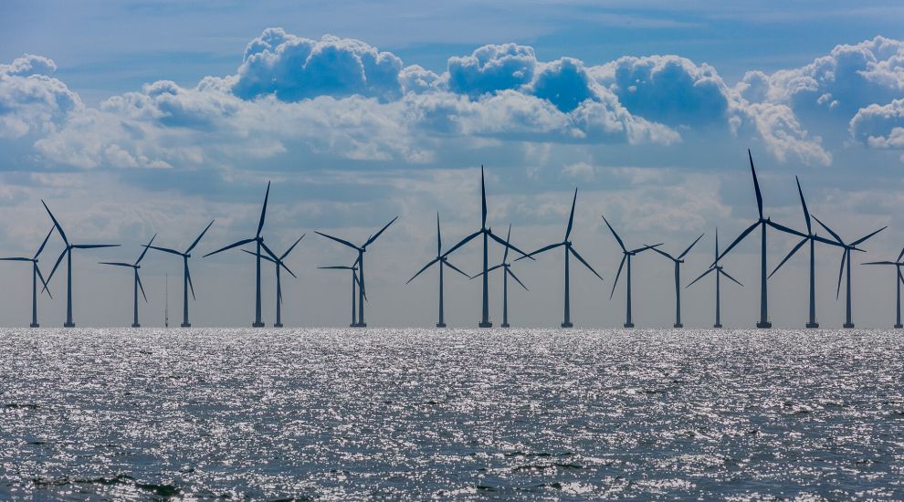
An obvious example of tension would be if the island decides to build an offshore wind farm.
A feasibility study in 2018 concluded that extracting energy from 5% of Jersey’s territorial waters would satisfy over three times the island’s current demand.

Pictured: Where Jersey could build an offshore wind farm within its territorial waters, as identified in the Bridging Island Plan.
A large area to the west of the island, stretching down to French territorial waters where a 500 MW wind farm is currently being built, is identified in the Bridging Island Plan as a suitable place location.
The 62 turbines currently being installed north of St Brieuc – each more than 200m high - will generate enough clean energy to power 835,000 homes.
Should Jersey invest in a project of its own, what about wildlife in the area? Where would the electricity come ashore? And what would happen to the sea bed?
Bringing another far-reaching Government document into the equation, the Carbon Neutral Roadmap sets an aim between now and 2030 of “continuing to explore the potential for blue carbon sequestration in Jersey’s waters”.
One of the Roadmap’s policies is to “promote Jersey as a centre of excellence for blue carbon sequestration, with an ambition to double the extent of sea grass beds and recognise that tackling the climate emergency by using nature-based solutions that also address the biodiversity crisis provides multiple benefits for our land, air and sea.”
Carbon capturing projects also get backing in the Bridging Island Plan.
It says: “Carbon sequestration schemes, including in the marine environment, will be supported where it is demonstrated that the development will lead to effective sequestration of carbon, in a location that is considered to be appropriate and will not otherwise lead to the unacceptable loss of agricultural land or have adverse impacts upon biodiversity or landscape or seascape character.”
So, if Jersey is going to double the size of its carbon-soaking sea grass and maerl beds, what happens to any fishing grounds in those areas? Indeed, how do you go about harvesting sea grass? What infrastructure is needed, if any?
It is these sort of questions that the Marine Spatial Plan will answer.
The Government says that the final version of the plan, which will be drafted by the Marine Resources Team within the Environment Department, will include:
Islanders who want to find out more and/or have their say are invited to one or all of five workshops which will be help in the coming weeks, each one with its own focus on topics.
These are:
Tuesday 28 February (15:00 – 17:00) - Biodiversity and cultural heritage,
Wednesday 1 March (15:00 – 17:00) - Coastal tourism and water sports,
Thursday 2 March (17:00 – 19:00) - Fishing (commercial and recreational) and aquaculture,
Friday 3 March (10:00 to 12:00) - Energy and infrastructure,
Monday 6 March (15:00 – 17:00) - General session, online only.
Those wishing to attend must register their interest by emailing the Marine Spatial Planning team on msp@gov.je.


Comments
Comments on this story express the views of the commentator only, not Bailiwick Publishing. We are unable to guarantee the accuracy of any of those comments.