Select a region


Plans for over 23% of the island's territorial waters to become marine-protected areas have been published following a lengthy consultation period.
The area set to be protected – 23.3% – has shrunk from the 27% originally proposed by the former Environment Minister.
The current Environment Minister Steve Luce said this iteration of the plans found "balance" between the different uses of the marine environment.
A visitor centre has also been proposed as part of the new plans, following multiple comments about a need to improve education regarding the marine environment.
More than 150 comments from all kinds of local businesses, charities, organisations and individuals, were taken into account when putting together the latest draft of the plan, which is set to be debated in the States Assembly this autumn.
The Environment, Housing and Infrastructure Scrutiny Panel will also scrutinise the document before that time.
Following the debate, and on the assumption that the plan is adopted, it will be republished. Work to build its priorities into policy for delivery will begin soon after, and the MSP will inform the next iteration of the Island Plan.
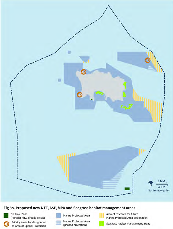
Pictured: The proposed new plans.
The MSP proposes a three-tier framework with different levels of protection in each tier: Regulated Fishing Zone, Seabed Protection Zone, and highly-protected No Take Zones.
The revised plans cover 55,265ha, or 23.3% of Jersey's marine area, and include the intertidal and nearshore zone, the offshore reefs, and outlying areas at Les Sauvages, Rigdon Bank and Banc Desormes.
In two specific areas within the MPA (on the south-eastern edges of Les Écréhous and Les Minquiers), protection is set to be phased in to "give the fishing community time to diversify their fishing methods and/or find alternative fishing grounds".
Two specific inshore areas (off the North Coast and the Corbière banks) will have seasonal restrictions on mobile gear. In these areas, use of mobile gear will only be permitted in the winter. Due to their noncontinuous closure to mobile gear, these areas are excluded from the MPA.
Recognising both Jersey's commitment to 30% MPA coverage by 2030 ('30 by 30'), and the importance of further research (into migratory fish species, seabed habitats, and into the effectiveness of the new MPAs), a number of additional areas are put forward for future consideration for MPA designation prior to 2030.
These include the area east of Les Écréhous; part of the basin between Les Écréhous and Les Anquettes, and areas to the east and west of Les Minquiers. Together the areas for further survey total 8,539ha (3.7% of Jersey's waters).
The document states: "More research of these areas — particularly related to migratory fish species, and the location of sensitive habitats such as ross worm habitats, kelp habitats and maerl — is needed to inform decisions on which areas become MPAs in the future.
"There is also potential to explore the use of biodiversity aids such as artificial reefs to enhance biodiversity within the MPA. Monitoring of MPAs will be essential to determining their effectiveness and in identifying future areas for MPA designation."
Deputy Steve Luce previously told States Members he was planning to make changes to the Marine Spatial Plan after local fishermen said proposals to protect 27% of the Island's territorial waters would decimate the industry.
Jersey Fishermen's Association president Don Thompson welcomed the move, which he said gave the fishing community "hope that there is a future for them".
A total of 154 responded to the consultation process, which was extended to allow more to respond.
According to the report: "The result is a document which reflects the wide-ranging concerns and aspirations of Jersey's residents with regard to the marine environment. Everyone involved shares a desire to see Jersey's seas thriving, and delivering benefits to people and to nature."
Following the consultation, changes are:

Pictured: the Environment Minister.
Deputy Steve Luce said: "I am grateful to everyone who took the time to give their views on the plan during the consultation period. We received over 150 comments which have all been taken into consideration when publishing this draft.
"I'd like to think that there is something positive for everyone in this revised plan, and especially for those who responded to the consultation.
"The plan helps us understand how people value and interact with our marine environment. It's important we find a balance between the different uses we have for our marine environment, and to make sure we interact with our local ecosystems in a sustainable manner."
The development of the Marine Spatial plan had a budget of £150,000 allocated to it under the Carbon Neutral Roadmap.
Project spend is close to £140,000, and developing the MSP has required 25% of the time of two Marine Resources officers over the last 18 months.
An attempt to create a marine park in 2022 covering more than a third of the Island's waters – brought forward by Deputy Lyndon Farnham – was rejected during the Bridging Island Plan debate.
That year, Jersey joined an international "30 by 30" pledge, part of a global initiative to conserve 30% of the globe's terrestrial and marine habitat and protect it from destructive practices by 2030.
Deputy Jonathan Renouf put forward new proposals for a Marine Spatial Plan last October which made an "evidence-based" case to expand an existing network of Marine Protected Areas to 27%.
Marine-protected area reductions give fishers "hope for a future"
New plans for Jersey Marine Park to cover third of territorial waters
EXPLAINED: How Jersey plans to manage 800 sq miles of coastal territory


Comments
Comments on this story express the views of the commentator only, not Bailiwick Publishing. We are unable to guarantee the accuracy of any of those comments.